

Indian Meteorological Department, on Sunday, warned that Cyclone Amphan, a “very severe storm”, will turn “extremely severe”. National Disaster Response Force (NDRF) has sent its 10 teams to Odisha and seven teams to West Bengal in view of the approaching Cyclone Amphan.
The weather agency said that the cyclone will cause heavy rainfall and high velocity wind in several coastal districts of Odhisa, West Bengal, and Andaman and Nicobar.
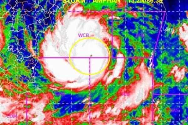
“The Severe Cyclonic Storm ‘Amphan’ (pronounced as UM-PUN) over central parts of South Bay of Bengal and neighbourhood moved slowly northwards resulting into severe cyclonic storm.
As per the post on twitter by the Indian Meteorological Department, “The Severe Cyclonic Storm ‘AMPHAN’ (pronounced as UM-PUN) further intensified into a Very Severe Cyclonic Storm over central parts of South Bay of Bengal, at 1430 IST of 17th May. It is very likely to intensify further into an Extremely Severe Cyclonic Storm during next 24 hour”.
The cyclone is likely to move nearly northwards slowly during next 12 hours and then re-curve north-northeastwards and move fast across northwest Bay of Bengal and cross West Bengal – Bangladesh coasts between Digha (West Bengal) and Hatiya Islands (Bangladesh) during the afternoon / evening of 20th May 2020 as a Very Severe Cyclonic Storm.
Light rainfall is expected in Andaman and Nicobar in the next 24 hours, the weather agency said.
“Rainfall (over Odisha & Gangetic West Bengal) Coastal Odisha is likely to experience light to moderate rainfall at many places with heavy falls at isolated places from 18 May evening. Rainfall at most places with heavy to very heavy rainfall at a few places on 19 May, and isolated heavy rainfall over north coastal Odisha on 20 May 2020,” it said.
Coastal districts of West Bengal are also likely to experience light to moderate rainfall at many places with heavy rainfall at isolated places on May 19.
“Squally wind speed reaching 45 to 55 kilometre per hour (kmph) gusting to 65 kmph is likely to commence along and off south Odisha coast from May 18 evening, extending to along and off north Odisha coast from May 19 morning. The wind speed will gradually increase becoming gale wind speed reaching 75 to 85 kmph gusting to 95 kmph from 20. morning along and off north Odisha and West Bengal coasts,” it said.
“It will gradually increase thereafter becoming 110 to 120 kmph gusting to 135 kmph along and on North Odisha coast and 120 to 140 kmph gusting to 155 kmph along and off West Bengal coast from the afternoon of 20 May 2020. Gale wind speed reaching 120-130 gusting to 145 kmph is prevailing over southeast and adjoining southwest Bay of Bengal. It is likely to increase becoming 140-150 gusting to 165 kmph over southern parts of central Bay of Bengal,” it added.
While cyclone AMPHAN is likely to make landfall off West Bengal coast on May 20, the National Disaster Response Force (NDRF) has sent its 10 teams to Odisha and 7 teams to West Bengal to tackle the cyclone. The NDRF is monitoring the situation and working with states and their disaster management teams, and the IMD.
Extremely Severe Cyclonic Storm ‘AMPHAN’ with Eye Pattern: 18th May 2020 (0730 to 0750 IST) pic.twitter.com/GAhQO3tGTz
— India Met. Dept. (@Indiametdept) May 18, 2020